Most rivers start high and end low. They follow gravity south and east, down from mountains and ridges, toward the sea. The St. Johns River does not do this. The St. Johns River starts nearly at sea level and runs north for 310 miles to the Atlantic Ocean — against every expectation, and with barely enough energy to get there.
It is the longest river in Florida. It is one of the few rivers in the United States that flows from south to north — a distinction it shares, in the rivers-that-flow-north club, with the Nile. And it is almost certainly the laziest river on the continent.
Here is what lazy means, in river terms. A river's gradient is the amount of elevation it loses between its source and its mouth. The Mississippi drops about 1,475 feet over its 2,340 miles. The Colorado drops over 14,000 feet. The St. Johns River, over 310 miles of northward travel through the full length of Florida, drops a total of 27 feet. That is less than three stories. One inch of drop per mile. The water does not so much flow as it barely refuses to stand still.
Twenty-seven feet. Over three hundred and ten miles. The water moves at approximately 0.3 miles per hour. A determined person on foot could walk upstream faster than this river runs downstream.
The river begins not as a mountain stream or a rushing headwater but as a marsh — a broad, flat expanse of sawgrass and wetland in Indian River County in central Florida, barely 27 feet above sea level. It seeps north through a chain of shallow lakes, widening as it goes, passing through the middle of the state and into northeast Florida. By the time it reaches the Jacksonville area it is two to three miles across in places. Then it turns east for the first and only time, passes through Mayport, and empties into the Atlantic Ocean.
The St. Johns River Water Management District describes it as one of the laziest rivers in the world. This is an official designation from the people whose job is to manage it. They are not being unkind. They are being accurate.
Now here is where it gets interesting.
Because the St. Johns moves so slowly and sits so close to sea level, the Atlantic Ocean at its mouth has enormous influence over it. Every day, twice a day, the ocean tide pushes inland. And because there is so little gradient pushing back — because the river has almost no momentum of its own — the tide wins. The tidal reversal on the St. Johns reaches more than 100 miles upstream from the mouth. In dry periods and under the right wind conditions, the Atlantic can push salt water all the way to Lake Monroe, 161 miles inland, reversing the river's direction entirely for days at a time.
The river that flows north can, and regularly does, flow south instead — driven not by gravity but by the sea.
What this creates, in the Jacksonville area specifically, is something unusual: a river that behaves more like an estuary than a typical freshwater channel. The lower St. Johns is brackish — a mixing zone where salt and fresh water interact continuously — and that ecosystem produces some of the most productive fisheries in Florida. Mullet, flounder, blue crab, redfish, and the famous Mayport shrimp all come from this water. The river doesn't flush cleanly. It circulates. It mixes. It gives back.
The Timucua people understood this river before any European ever saw it. They called it Welaka — "river of lakes" — and they lived along its banks for thousands of years, fishing its slow water and reading its tides. The Spanish arrived in the 1560s, named it Río de San Juan, and built St. Augustine nine miles east, partly because the river provided a defensible water boundary to the west. The French had tried to establish Fort Caroline at the river's mouth in 1564. The Spanish eliminated the French colony in 1565 and Fort Caroline with it — the same year they founded St. Augustine, now the oldest continuously occupied European settlement in the country.
Every major event in northeast Florida's early history happened along or because of this river. It was the highway before there were highways. The steamboats came in the 1820s, running tourists and freight from Jacksonville south through the lake country. By the 1880s, wealthy northerners were taking steamboat tours up the St. Johns the way people today drive A1A. Henry Flagler — the same man who paid $10,000 to move St. Augustine's jail — extended his railroad down the east coast because the river had already proven the route.
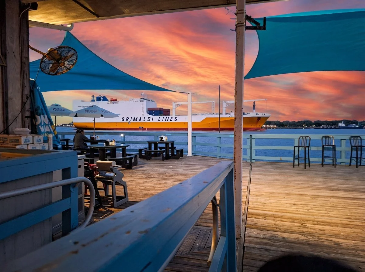
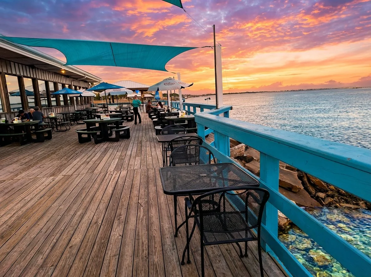
Today the lower St. Johns carries approximately 16 million tons of freight through the Port of Jacksonville annually. Container ships, vehicle carriers, and tankers move through the same channel where the Timucua fished and the Spanish built their colony. The Sandollar Restaurant on Heckscher Drive has a deck that sits at the rail with the shipping channel three feet below — when a Grimaldi Lines freighter comes through at sunset, you feel it before you see it. The USS Orleck, a Cold War destroyer with 14 battle stars, is docked permanently on the St. Johns riverfront in downtown Jacksonville. The Mayport Ferry crosses it every thirty minutes, connecting Heckscher Drive to Fort George Island — the same crossing the Timucua made by canoe.
Where You Can See the St. Johns River
The river also supports manatees — Florida's gentle, perpetually sunburned sea cows — who follow the warm tidal water inland and gather at the spring runs that feed the upper St. Johns in winter. More than a hundred springs flow into the watershed, some of them producing crystal-clear 72-degree water year-round. Blue Spring State Park, west of Orlando, is a designated manatee refuge where hundreds of them gather from November through March. On the lower river near Jacksonville, dolphins are common year-round in the mixing zone at the mouth.
Over 170 species of fish inhabit the river across its 310-mile course — largemouth bass in the freshwater reaches, tarpon in the tidal lower section, shrimp and blue crab in the estuary. The St. Johns Riverkeeper, a nonprofit that has been monitoring and protecting the river for decades, calls it one of the most biodiverse river systems in the eastern United States. It is also, they note with concern, one of the most threatened — nitrogen runoff from agriculture and septic systems, harbor deepening that pulls saltwater further upstream, and sea level rise that will push that saltwater further still. The river that barely moves has very little capacity to flush what goes into it.
The St. Johns River flows north for 310 miles. It drops 27 feet — one inch per mile — over that entire journey. It moves at 0.3 miles per hour. It is one of the laziest rivers on earth.
Because it barely moves, the Atlantic Ocean can reverse it entirely. Twice a day the tide pushes inland, and in low-water periods the river runs backward — southward — for over 100 miles. A river that flows north can, and does, flow south instead.
It shares its northward distinction with the Nile. It has carried Timucua fishermen, Spanish colonists, French settlers, American steamboat tourists, and 16 million tons of annual freight through the same channel. Every major event in northeast Florida's history happened on or because of this water.
And right now, if you sit on the deck at the Sandollar Restaurant on Heckscher Drive and watch the current, you probably cannot tell which direction it is moving. Neither, on any given afternoon, can the river.
Good day.
The St. Johns River runs through or alongside nearly every destination on this site. Learn more about it at stjohnsriverkeeper.org — or better yet, go sit on a deck somewhere along Heckscher Drive and watch a freighter go by.